-
Background
-
Aerial views
-

Aerial view of Tinnis Castle Hillfort, Canmore image SC 993210
© Crown Copyright: HES
Aerial view of Tinnis Castle Hillfort from SW
-
Scottish nucleated and vitrified forts
-

Tinnis Castle Hillfort is thus especially interesting as it offers the opportunity to examine similarities with other nucleated and vitrified forts elsewhere in Scotland but also what distinguishes this hillfort from the many other hillforts in the Scottish Borders.
Indeed, the area of Peeblesshire surrounding Tinnis Castle is particularly rich in hillforts and forms part of a cluster within Upper Tweeddale and Upper Clydesdale separate from distributions across the Lothians, Dumfriesshire and the central and eastern Borders. Henry’s Brae lies on an adjacent ridge and comprises a single stone rampart enclosing a much larger area containing at least 28 round-house platforms.
Across the valley lies Dreva Craig, a hillfort containing several roundhouses, enclosed by two ramparts, chevaux de frise set out on its approaches and associated with several clusters of outlying settlements.
Further south-west on the other side of the valley is Rachan Hill, which is also enclosed by the remains of two stone ramparts and contains the remains of several roundhouses within its interior. While these hillforts, like most such enclosed hilltop settlements, are understood to be Iron Age, Tinnis Castle Hillfort stands out as the most likely contender for an early medieval date, a period from which there is as yet very little archaeological evidence recovered from the Scottish Borders and which only a handful of known settlements are considered to date from.
The very name of the hill itself may indicate an early medieval origin. Tinnis derives from the word dinas, meaning ‘fort’ from the Cumbric (or ancient Welsh) language which was spoken in southern Scotland during the early medieval period. Dinis is prevalent in Cornwall while Dinas is common in Wales where the same language was spoken at the time.
However, these indicators are not sufficient to conclusively date Tinnis Castle Hillfort. In August 2022, three excavation trenches will target two parts of the main summit rampart and one of the outer ramparts to gather sufficient archaeological evidence for the date and nature of occupation of the site.
The excavation will enhance understanding of the hillfort underlying Tinnis Castle by establishing the dates for its construction and destruction, and the duration and nature of occupation.
-
Thirlestane Barrows
-
Proposed trenches
-

Background
The ruins of Tinnis Castle occupy a prominent rocky knoll overlooking the Upper Tweed valley at Drumelzier in Peeblesshire. The site is a scheduled monument. The traces of masonry indicate a fifteenth – early sixteenth century date for its construction by the Tweedies of Drumelzier, who held this land from the early fourteenth to the early seventeenth century.
It was destroyed around 1525 by the Flemings during a feud with the Tweedies at this time. However, it is not the castle that will be the subject of this archaeological investigation but the underlying hillfort.
This hillfort is defined by the remains of a rampart enclosing the natural summit of the knoll, supplemented by the remains of two non-concentric outer ramparts, on the north-east and south-west flanks of the knoll.
This layout – a fortified summit with a series of lesser enclosures looping out along lower-lying terraces and crags – is typical of a ‘nucleated fort’, a type of hillfort unique to Scotland between circa AD 600 to AD 900.
Nucleated forts are quite rare in the Scottish Borders. Only two others are found in Peeblesshire, another four further south-east in Roxburghshire. The cluster of nucleated forts around Tinnis Castle is found within a 100 km² area of Peeblesshire that coincides with two Romano-British Christian monuments.
While not all early medieval nucleated forts occur in clusters, it is nevertheless apparent that several clusters of nucleated forts exist in Scotland. This includes the cluster of nucleated forts 40 km away in Roxburghshire; one of these, Rubers Law, yielded Roman masonry suggesting a post-Roman date.
Another cluster of nucleated forts lies within a 700 km² area of the Stewartry district of Galloway and another within a 400 km² area centred upon Dunadd in Argyll. This might indicate that a similar cultural process, that led to clusters of nucleated forts in other parts of Scotland, also occurred in the Scottish Borders.
However, unlike these other areas where excavations have revealed nucleated forts to be high status settlements of the early medieval period, none of the Scottish Borders sites have yet been excavated.
The summit rampart is particularly interesting because vitrified stone has previously been recorded below its south-west corner. This indicates that this was originally a timber-laced rampart that was deliberately burnt to the ground, causing the rubble to vitrify.
This phenomenon is apparent on over 100 hillforts across Scotland that can date to anywhere between 800 BC to AD 900, from the Iron Age to the early medieval period. Vitrified hillforts are particularly unusual in the Scottish Borders and indeed south-east Scotland, with only one other recorded in the Borders, that at Black Hill near Earlston, and only three others across the Lothians.
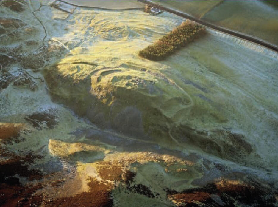
Aerial view of Tinnis Castle Hillfort, Canmore image SC 993210
© Crown Copyright: HES
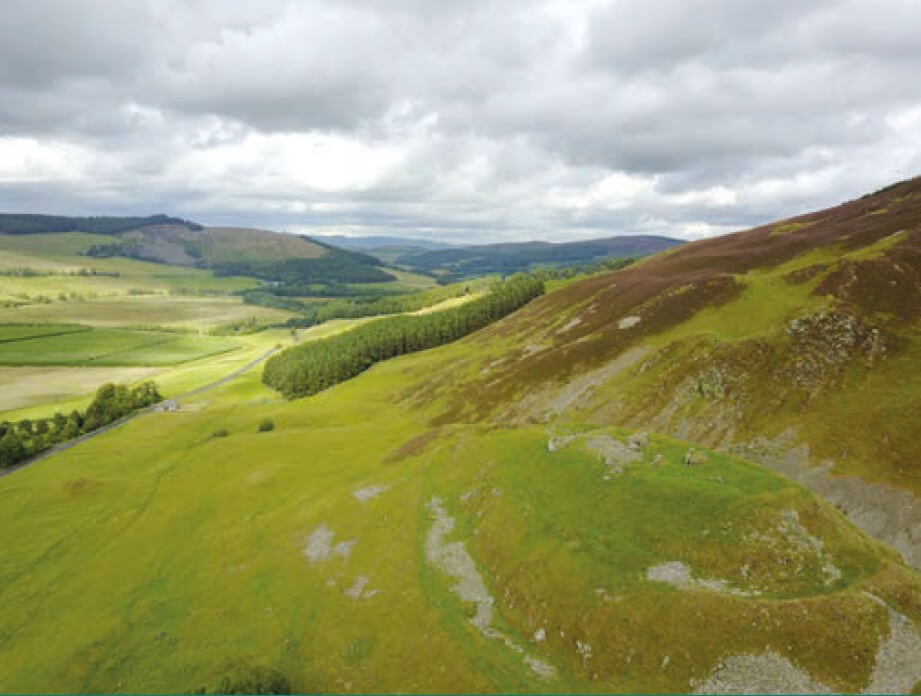
Aerial view of Tinnis Castle Hillfort from SW

Tinnis Castle Hillfort is thus especially interesting as it offers the opportunity to examine similarities with other nucleated and vitrified forts elsewhere in Scotland but also what distinguishes this hillfort from the many other hillforts in the Scottish Borders.
Indeed, the area of Peeblesshire surrounding Tinnis Castle is particularly rich in hillforts and forms part of a cluster within Upper Tweeddale and Upper Clydesdale separate from distributions across the Lothians, Dumfriesshire and the central and eastern Borders. Henry’s Brae lies on an adjacent ridge and comprises a single stone rampart enclosing a much larger area containing at least 28 round-house platforms.
Across the valley lies Dreva Craig, a hillfort containing several roundhouses, enclosed by two ramparts, chevaux de frise set out on its approaches and associated with several clusters of outlying settlements.
Further south-west on the other side of the valley is Rachan Hill, which is also enclosed by the remains of two stone ramparts and contains the remains of several roundhouses within its interior. While these hillforts, like most such enclosed hilltop settlements, are understood to be Iron Age, Tinnis Castle Hillfort stands out as the most likely contender for an early medieval date, a period from which there is as yet very little archaeological evidence recovered from the Scottish Borders and which only a handful of known settlements are considered to date from.
The very name of the hill itself may indicate an early medieval origin. Tinnis derives from the word dinas, meaning ‘fort’ from the Cumbric (or ancient Welsh) language which was spoken in southern Scotland during the early medieval period. Dinis is prevalent in Cornwall while Dinas is common in Wales where the same language was spoken at the time.
However, these indicators are not sufficient to conclusively date Tinnis Castle Hillfort. In August 2022, three excavation trenches will target two parts of the main summit rampart and one of the outer ramparts to gather sufficient archaeological evidence for the date and nature of occupation of the site.
The excavation will enhance understanding of the hillfort underlying Tinnis Castle by establishing the dates for its construction and destruction, and the duration and nature of occupation.
The results of the Tinnis Castle Fort Dig will be examined in comparison with the dating evidence from the survey and excavation of Thirlestane Barrows in October 2022, which form another part of the same project.
The barrows were only recently discovered in two fields south of Broughton, when during the dry ground conditions of summer 2018, cropmarks were spotted from a nearby hillside by a local resident. An aerial photographic survey in July 2018 further revealed that these cropmarks included at least four potential barrow graves.
Three of these barrow cropmarks comprise circular ditches enclosing a small area with a central feature.
The fourth barrow cropmark comprises a square shaped ditch enclosing a small area containing a central feature. Where sites such as this have been excavated, the central feature is a grave, which was originally buried beneath a small mound of earth cast from the enclosing ditch. However, ploughing over the subsequent centuries has usually removed the mound, leaving only the buried archaeological remains, which are often only visible from the air.
Such barrow graves can be Iron Age or early medieval in date. It is likely that these barrow graves represent the graves of some of the inhabitants of the numerous hillforts that are distributed around this location. In particular, do these burials relate to the occupation of Tinnis Castle Hillfort, which lies approximately 1 mile to the east.
The project will undertake geophysics surveys of these two fields and two small excavation trenches to confirm that these are indeed barrow graves and what archaeological evidence they contain.
Geophysics is a non-intrusive survey technique that can identify potential archaeological features buried beneath the surface. It often reveals many more archaeological features than aerial photography. The excavation of small trenches across the square barrow and one of the round barrows will verify what these archaeological remains are.